GeoEDGE is a limited liability company specializing in the design and development of innovative software solutions for both web and mobile platforms. Our core services include the design, development, and implementation of Knowledge and Information Management Systems, Learning Management Systems (LMS), Enterprise Resource Planning (ERP) solutions, Geographic Information Systems (GIS), remote sensing, mapping, and a wide range of customer-driven business applications.
In addition to software development, GeoEDGE possesses strong expertise in DevOps, IT infrastructure, and cybersecurity. Our dedicated international team has extensive experience in software and application development, website and mobile app design, Azure cloud infrastructure implementation, on-premises to cloud server migrations, data backup strategies, cybersecurity risk assessments, and the design of secure, scalable IT and network architectures.
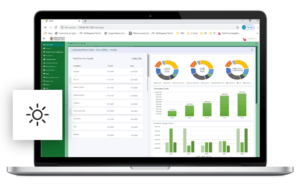
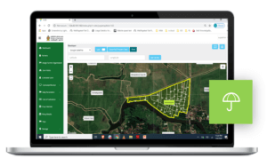
GeoEDGE developed AIMS as a centralized digital platform to modernize the agriculture sector’s information flow and decision-making. The system connects farmers, insurers, government agencies, and agribusinesses through a shared interface featuring land plot mapping, stakeholder management, and crop lifecycle tracking. AIMS integrates a custom-built “Index-Based Insurance” algorithm to streamline claim processing and damage assessment, while transforming raw, file-based data into an actionable digital format accessible through user-specific dashboards and mapping tools.
“AIMS empowers agriculture stakeholders with data clarity, faster coordination, and smart tools for better decisions.”
Process & Results
The project began with a deep dive into existing workflows, identifying bottlenecks in data handling and coordination across agricultural departments. GeoEDGE built AIMS with modular functionality to support admin roles, user access controls, and intuitive dashboards. Features include digital land plot registration, data analytics, mapping tools, and end-to-end management of crop information, claims, and reports.
The system’s scalable architecture enables future upgrades and integration with external datasets. AIMS now serves as a baseline data repository and digital coordination platform for agencies and farmers, significantly improving efficiency, transparency, and informed decision-making across the agricultural ecosystem.